
VANCOUVER, BC , Feb. 8, 2023 – Canada’s oceans play an essential role in the lives of Canadians from coast to coast to coast. They are critical to all life on the planet, are home to a vast array of species and organisms, help regulate the Earth’s climate, and play a significant role in our heritage, culture, and economy. The Government of Canada is taking action to further protect our oceans, so that future generations can continue our tradition as a proud ocean nation and enjoy the many benefits of healthy marine ecosystems.
Today, during the Fifth International Marine Protected Areas Congress (IMPAC5), the Honourable Joyce Murray, Minister of Fisheries, Oceans and the Canadian Coast Guard, and the Honourable Steven Guilbeault, Minister of Environment and Climate Change and Minister responsible for Parks Canada, announced key developments that continue the momentum towards Canada meeting its ambitious targets of conserving 25 per cent of Canada’s oceans by 2025 and 30 per cent by 2030.
To start, Canada unveiled its 2023 Marine Protected Area (MPA) Protection Standard, which is endorsed by Fisheries and Oceans Canada, Environment and Climate Change Canada, Parks Canada, Natural Resources Canada, Crown-Indigenous Relations, and Transport Canada. The 2023 protection standard builds on and clarifies the original 2019 policy, which was based on recommendations from the National Advisory Panel on MPA Standards and applies to federal MPAs established since April 25, 2019. MPAs are an essential part of achieving marine conservation goals, and the protection standard will help safeguard new federal MPAs from the potentially harmful effects of some industrial activities. It will also provide greater consistency and clarity for industry on activities subject to the standard in federal MPAs.
The MPA Protection Standard is founded on a whole-of-government approach and prohibits:
- Oil and gas exploration, development and production;
- Mineral exploration and exploitation;
- Disposal of waste and other matter, dumping of fill, and deposit of deleterious drugs and pesticides; and
- Mobile, bottom contact, trawl or dredge gear. Trap-based fisheries are excluded.
Transport Canada will also be consulting with stakeholders on how to enhance restrictions on certain vessel discharges that occur within MPAs.
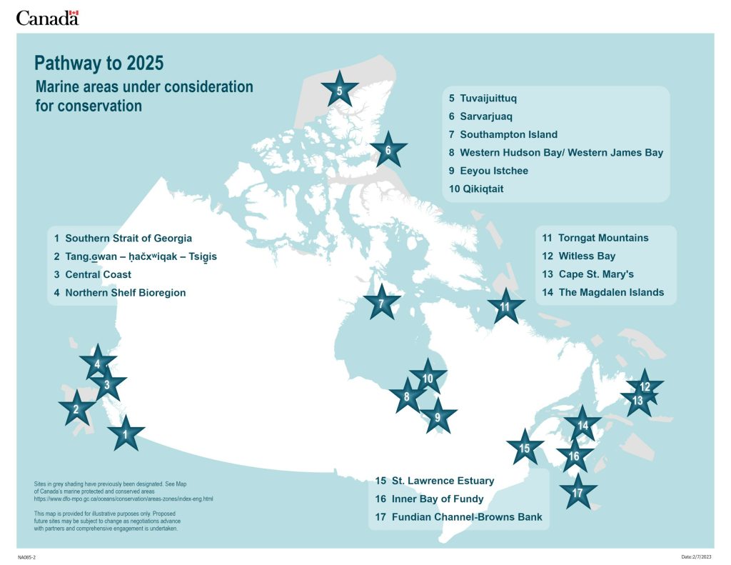
In addition to the protection standard announced today, Canada also released new details on key areas where it is exploring marine conservation, in support of the ambitious target of conserving 25 per cent of our ocean by 2025. This builds on announcements earlier this week that underscore Canada’s commitment to advancing its targets, and include the Northern Shelf Bioregion Network Action Plan, a marine refuge at Gwaxdlala/Nalaxdlala – also known as Lull Bay and Hoeya Sound, and the collaborative management and upcoming pre-publication of the proposed regulations for the Tang.ɢwan – ḥačxwiqak – Tsig̱is Marine Protected Area (MPA) in the Canada Gazette, Part I for a 30-day public comment period.
While proposed future sites are at different stages of readiness, the Government of Canada is working closely with key partners and stakeholders including provinces and territories, Indigenous governments, organizations across the country, who understand the critical importance, now more than ever, of safeguarding our ocean for the future, while enabling sustainable economic development opportunities.
Today’s announcement is an important step towards the conservation and long-term protection of our marine ecosystems, and furthers Canada’s position as a world leader in marine conservation. Having well-understood standards will help boost conservation efforts while at the same time provide industry with the clarity it needs to create sustainable jobs in the marine sector.
Quotes
“Canada is a proud ocean nation, with the longest coastline in the world. The ocean plays a central role in climate regulation and are vital to our way of life. Canadians expect us to protect the environment, and today’s announcement does just that. With a strong protection standard, and an ambitious plan for new sites that will help us reach Canada’s targets to conserve 25 per cent of our oceans by 2025, we are well positioned to preserve oceans effectively for generations to come.”
The Honourable Joyce Murray, Minister of Fisheries, Oceans and the Canadian Coast Guard
“Today’s announcement marks a key milestone on our path to reaching thirty percent protection of Canada’s oceans by 2030. When Canada stepped up to host the U.N.’s COP15 biodiversity conference in Montreal last fall, we played a lead role in getting the whole world to agree to the 30 by 30 targets that we are striving for here in Canada. Protecting healthy ocean ecosystems protects the future of thousands of coastal communities and thousands of marine species. The new protection standard announced today will go a long way to strengthen the level of protection in marine areas.”
The Honourable Steven Guilbeault, Minister of Environment and Climate Change and Minister responsible for Parks Canada
“Canada’s oceans are a vital part of our history, identity, economy and environment. From coast to coast to coast, healthy ocean ecosystems have supported valuable biodiversity and countless jobs. The Marine Protected Area Protection Standard will help us ensure that our oceans, coasts and waterways are preserved for future generations.”
The Honourable Jonathan Wilkinson, Minister of Natural Resources
“Indigenous Peoples have always guarded this continent’s natural resources, making their knowledge and partnership key to strong management and conservation. We will continue to work with Indigenous Peoples to integrate Indigenous knowledge and ensure the best possible protection of Canada’s waters. Our continual work to renew and transform the MPA Protection Standard is a welcome example of the progress that can be made by working together to protect our environment, resources and planet.”
The Honourable Marc Miller, Minister of Crown-Indigenous Relations
“The Oceans Protection Plan is a Canadian success that allows us to continue to achieve our goals to protect our coasts and oceans while growing our economy and creating good middle class jobs. Today’s announcement is good news and will help safeguard new federal marine protected areas from the potentially harmful effects of industrial activities.”
The Honourable Omar Alghabra, Minister of Transport
Quick Facts
- A marine protected area, commonly called an MPA, is part of the ocean that is legally protected and managed to achieve the long-term conservation of nature. MPAs and other effective area-based conservation measures (OECMs) contribute to a healthy marine environment and offer a nature-based solution to help address the impacts of climate change and biodiversity loss by protecting marine ecosystems, habitats, and species.
- In July 2020, Canada joined the Global Ocean Alliance which is advocating to protect at least 30 per cent of the world’s oceans by 2030.
- In December 2022, Canada stepped up to host 195 members of the United Nations Convention on Biological Diversity, COP15, the largest biodiversity conference of its kind. Canada played a pivotal role in brokering a historic agreement to safeguard the world’s nature and to protect 30% of lands and waters by 2030.
- Canada announced its Protection Standards for MPAs and Other Effective Area-Based Conservation Measures (OECMs) at the Nature Summit in 2019 following work of the independent National Advisory Panel on Marine Protected Area Standards. The Panel provided its recommendations in a final report to the Minister of Fisheries, Oceans and the Canadian Coast Guard in September, 2018. Today’s announcement pertains to the MPA standard only.
- The Protection Standard for OECMs remains unchanged; proposed activities in OECMs continue to be assessed on a case-by-case basis and may be allowed to proceed if the risks to the area can be effectively avoided or mitigated.
- On February 23, 2022, the Minister of Environment and Climate Change Canada and Minister responsible for Parks Canada signed a Memorandum of Understanding with the President of the Nunatsiavut Government to examine the feasibility of establishing an Indigenous Protected Area along the northern coast of Labrador, under the Canada National Marine Conservation Areas Act.
- On June 8, 2022, the Eastern Canyons Marine Refuge was established, adding 0.76% for a new total of 14.66% of our ocean conserved.
- On December 9, 2022, DFO published the Government of Canada’s 2022 Guidance for Recognizing Marine Other Effective Area-Based Conservation Measures (OECM).
- On February 5, 2023, the Government of Canada, the Mamalilikulla First Nation, and the Province of British Columbia announced fisheries closures and the establishment of a marine refuge, to help protect the ecologically and culturally significant area of Gwaxdlala/Nalaxdlala in Knight Inlet on the coast of British Columbia.
Related Products
- Marine Protected Areas Protection Standard (Backgrounder – link)
- Pathway to 2025 (Backgrounder – link)
Associated Links
- Marine Protected Areas (MPA) Protection Standard
- Other Effective Area-Based Conservation Measures (OECM) Protection Standard
- Marine protected areas across Canada
- Establishing new marine protected areas
- National Advisory Panel on Marine Protected Area Standards
- IMPAC5
- National marine conservation areas – Parks Canada
Stay Connected
- Follow Fisheries and Oceans Canada on Twitter, Facebook, Instagram, YouTube and LinkedIn.
- Follow the Canadian Coast Guard on Twitter, Facebook, Instagram, YouTube and LinkedIn.
Backgrounder
Canada’s path to 25 per cent ocean protection by 2025
In 2015, less than one percent of our ocean space was protected. Today, that figure stands at 14.66 per cent and is comprised of:
- 14 Oceans Act Marine Protected Areas;
- 2 National Marine Conservation Areas;
- 1 Marine Park
- 13 National Parks with marine components;
- 1 marine National Wildlife Area, and
- 60 other effective area-based conservation measures or marine refuges.
The Government of Canada is unveiling the proposed future sites being considered for conservation on our path to 25 per cent by 2025, and we are confident in reaching our goal. We recognize that a great deal of work still lies ahead. Reaching our targets is indeed an ‘all in’ effort – building upon and sustaining those meaningful partnerships with governments at all levels, Indigenous peoples, industry, environmental non-governmental organizations and academia.
Together, we continue to make progress on all elements of our plan, which includes:
- Establishing new sites (this includes Marine Protected Areas (MPAs) other effective area-based measures (OECMs);
- Effectively managing new and existing sites, and enforcing our protection standards;
- Working to achieve shared ecological, economic, cultural and social objectives in the marine environment by using Marine Spatial Planning; and
- Continuing to advocate for the 30-by-30 targets internationally with the hope that, in time, 100 per cent of the world’s oceans will be sustainably managed.
Each of the proposed sites is at a different stage of readiness.
Decisions about which sites to pursue for conservation (and what legal tool to use) continue to be made in consultation with partners and stakeholders. These decisions are based on science and data, Indigenous knowledge and strong socio-economic analysis.
By continuing to work together in a genuine spirit of cooperation and in ways that respect and incorporate the views of our many partners, we expect that Canada will reach its target of conserving 25 per cent of Canada’s oceans by 2025.
1. Southern Strait of Georgia
The Southern Strait of Georgia is an island-strewn area in one of the most populated and heavily visited regions in Canada, extending from the southern tip of Gabriola Island to Saanich Inlet and Cordova Bay, just north of Victoria, BC.
Estuarine areas like the Strait of Georgia are among the most productive marine ecosystems in the world due to fresh water and ocean water mixing and upwelling to create a nutrient-rich marine environment. The area is known for its rich assemblages of marine plants and animals ranging from lush kelp forests to a diversity of invertebrate, fish, bird and marine mammal species. The proposed national marine conservation area (NMCA) reserve would represent the Strait of Georgia marine region, one of 29 marine regions that constitute Parks Canada’s National Marine Conservation Area System Plan.
Currently, work is progressing on the establishment of a steering committee that includes First Nations and the Governments of Canada and British Columbia. The steering committee will oversee the development of a long-term vision for the area, a proposed boundary, engagement with stakeholders, and recommendations to leadership on whether a NMCA reserve in the area is feasible.
2. Tang. ɢwan — ḥačx wiqak — Tsig̱is
Tang.ɢwan — ḥačxwiqak — Tsig̱is is located west of Vancouver Island, British Columbia; in the Offshore Pacific Bioregion and is being advanced in partnership with the Nuu-chah-nulth Tribal Council, the Council of the Haida Nation, Pacheedaht First Nation, and Quatsino First Nation. We look forward to advancing public consultation as the next phase of our work together.
The proposed Conservation Objective is to contribute to the protection and conservation of the unique seafloor features (i.e., seamounts and hydrothermal vents) and the ecosystems they support in Canada’s Offshore Pacific Bioregion.
Science shows that there are benefits linked to protecting large marine areas in a precautionary manner. Large marine areas typically contain several ecosystems and habitats that interact ecologically at various spatial scales, therefore allowing for holistic conservation opportunities. Large MPAs may capture one or more examples of significant areas (e.g., EBSAs) – while also ensuring that particular elements of biodiversity (e.g., species, communities) and some physical characteristics (e.g., oceanographic properties, geological features) are protected.
3. Central Coast
Highly scenic fjords, long sand beaches, and an archipelago to open sea characterize this region. This area is adjacent to the Great Bear Rainforest and encompasses high concentrations of marine mammals and some of the largest kelps beds in BC. For millennia, the wellbeing of the Heiltsuk, Kitasoo Xai’Xais, Nuxalk and Wuikinuxv Nations have been linked, inextricably, to the health of the marine environment. Management and use of abundant marine resources, particularly salmon, eulachon and herring, supported ancient civilizations and allowed rich and complex cultures and societies to develop. Archeologists have dated the origins of village sites on the Central Coast as far back as 14,000 years – making them some of the oldest continually occupied sites in Canada.
It was the Nations who first approached the Government of Canada, seeking a partnership to protect this important area. The proposed site represents the Queen Charlotte Sound Marine Region of Canada’s national marine conservation area system. On August 6, 2021, Parks Canada, the Province of British Columbia, and the Heiltsuk, Kitasoo Xai’xais, Nuxalk, and Wuikinuxv Nations signed a Memorandum of Understanding (MOU) to launch a feasibility assessment for a proposed national marine conservation area reserve on the Central Coast of British Columbia.
This partnership represents a convergence of traditional knowledge and western science and a tri-partite collaboration to protect this area.
4. Northern Shelf Bioregion
The Northern Shelf Bioregion (NSB) stretches from Campbell River, north to the B.C.–Alaska border. The MPA Network planning process began in 2015 and has involved years of consultation, planning, and collaboration involving coastal First Nations, industries, stakeholders, provincial and federal partners, and coastal communities and peoples.
The rich ocean waters, expansive coastline, and aquatic vegetation of the Northern Shelf Bioregion are home to an abundance of marine species. This region supports over 64 species of fish (e.g. salmon and rockfish), 70 species of marine birds (e.g. puffins and auklets), 30 species of marine mammals including orcas, sea otters, dolphins, and 52 species of invertebrates like shellfish, sea urchins, octopus, and squid.
With the joint endorsement by the 15 Coastal First Nations, the Government of Canada and the Province of B.C., the Action Plan can now be used to inform the implementation of an MPA Network in the NSB using a planned approach. It identifies new areas that contain collaboratively identified ecological and cultural conservation objectives to be considered for protection using Indigenous, provincial, and federal spatial protection tools, which may also contribute to Marine Conservation Targets for 2025 and 2030.
5. Tuvaijuittuq
Tuvaijuittuq is the first MPA to be designated by Ministerial Order under the Oceans Act. Located off the northwest coast of Ellesmere Island, Nunavut in the Arctic Ocean, it includes the marine waters off northern Ellesmere Island starting from the low water mark and extending to the outward boundary of Canada’s Exclusive Economic Zone.
Tuvaijuittuq, meaning “the place where the ice never melts” in Inuktut, is located in an area that has been used by Inuit for travel and harvesting. This culturally and historically significant marine area is considered globally, nationally and regionally unique due to the presence of multi-year pack ice.
Working with the Qikiqtani Inuit Association and the Government of Nunavut towards long term protection of this area will contribute to the conservation, protection and understanding of the natural diversity, productivity and dynamism of the High Arctic sea ice ecosystem. Sea ice provides habitat for ice-adapted organisms, such as microscopic algae, that form the basis of, and provide energy for, Arctic marine food webs all the way up to marine mammals and polar bears.
6. Sarvarjuaq
Sarvarjuaq, also known as the North Water Polynya, is located in northern Baffin Bay between Canada and Greenland. It is the largest open-water area surrounded by ice in the Arctic, and Inuit-led conservation of this area is being advanced in partnership with the Qikiqtani Inuit Association.
This area is one of the planet’s most productive ecosystems, and its high rates of biodiversity, biological productivity support an abundance of marine life. It is a key feeding area and migration corridor for seabirds, fish, and mammals such as narwhal, walrus, beluga and bowhead whales, ringed bearded and harp seals, and polar bears.
The conservation priorities would seek to mitigate negative impacts associated with climate change, and potential increases in anthropogenic activities (e.g., shipping).
7. Southampton Island
The nearshore waters around Southampton Island and Chesterfield Inlet are in the Kivalliq Region of Nunavut. This site occurs within the Hudson Bay Complex Marine Bioregion and captures important portions of Southampton Island, Repulse Bay/Frozen Strait, and Western Hudson Bay Coastline Ecologically and Biologically Significant Areas.
This area provides a migration pathway for marine mammals, important haul-out sites for walrus, as well as denning areas and summer refuge for polar bears. The Eastern Canada-West Greenland bowhead whale population can be found in the area around Southampton Island, while the Western Hudson Bay Coastline area is particularly important during the ice-free season for beluga and killer whales. The marine area also supports colonies of seabirds like nesting common eiders and Arctic char stocks that feed in the area.
The proposed overarching goal is to conserve and protect the ecological integrity of the area. Inuit-led conservation of this area is being advanced in partnership with the Kivalliq Inuit Association and territorial partners.
8. Western Hudson Bay/ Western James Bay
The waters of Western Hudson Bay/Western James Bay are home to threatened and endangered species, including beluga whales and polar bears, while also supporting estuarine fish populations, eelgrass meadows, and an important global migratory bird stopover. This region plays a vital role in the cultural and economic history of the Omushkego Cree People.
This proposed marine area is adjacent to one of the largest stocks of carbon-rich peatlands in the world called the “breathing lands” by Elders. These ancient wetlands play a very important role in cooling the planet. While the marine and peatland ecosystems support each other, they are also critical to supporting the culture and traditions of the Omushkego people.
On August 9, 2021, the Government of Canada and the Mushkegowuk Council, signed a memorandum of understanding (MOU) to launch a feasibility assessment for a national marine conservation area in western James Bay and southwestern Hudson Bay.
9. Eeyou Istchee ( Eastern James Bay, Quebec and Ontario)
In May 2019, the Government of Canada and the Crees of Eeyou Istchee signed a Memorandum of Understanding (MOU) to assess the feasibility of creating a national marine conservation area (NMCA) in eastern James Bay. The study area for the proposed NMCA is found within the James Bay Marine Region, one of the 29 marine regions that make up Parks Canada’s NMCA system.
Stretching from Chisasibi, in Eeyou Istchee (northern Quebec), south to the Quebec-Ontario border. Eeyou Istchee—the Cree lands and waters in Eastern James Bay, the study area is rich in biodiversity. Many rivers flow through the area, bringing large amounts of freshwater to the Bay. This creates a special marine environment with a low concentration of salt.
As a part of the larger Hudson Bay inland sea, James Bay is also a hub for migrating geese, ducks, and shore birds. Enhancing the protection of these ecosystems both conserves biodiversity and fights climate change. This would also support the treaties and rights of the Eeyou (Crees) of Eeyou Istchee and their determination to maintain their culture and way of life. The Eeyou have been stewards to these lands and waters since time immemorial.
10. Qikiqtait
Qikiqtait encompasses an archipelago of over 1,500 islands and adjacent marine waters located off the western coast of Quebec in southeastern Hudson Bay and it is home to the southernmost community in Nunavut’s Qikiqtaaluk Region, Sanikiluaq. Inuit-led conservation of this site is being advanced in partnership with the Qikiqtani Inuit Association, local boards and organizations.
This area houses critical marine and terrestrial habitats, both seasonally and year-round. It is a refuge, feeding area, and migratory corridor for marine mammals (e.g., seals, belugas, polar bears, walrus), fish (e.g., Arctic char), and seabirds (e.g., Arctic eider duck). It encompasses up to 35 recurrent polynyas, and the coldest summer sea-surface temperatures in Hudson Bay south of Southampton; this sustains high invertebrate populations (e.g., sea urchins, cucumbers, bivalves).
The conservation goals will be led by community interest in protecting their unique, complex, and sensitive marine and coastal environment, including mitigating negative impacts of climate change and outside anthropogenic activities.
11. Torngat Mountains ( Northern Labrador coast)
The Government of Canada and the Nunatsiavut Government signed a Memorandum of Understanding (MOU) in February 2022 to continue work to assess the feasibility of establishing an Inuit Protected Area under the Canada National Marine Conservation Areas Act.
The study area is located in the coastal and marine areas of northern Labrador and adjacent to Torngat Mountains National Park. Northern Labrador has been an area of continuous human use and settlement for nearly 10,000 years. Inuit have been stewards of this region since time immemorial and they continue to practice their traditions on its lands and waters.
The study area includes coastal and offshore waters adjacent to Torngat Mountains National Park in northern Labrador within the Labrador Shelf Marine Region. Its known for its importance as a critical area for visiting narwhals, ringed seals, Arctic char, breeding and migrating seabirds and waterfowl, and is a unique migratory area for endangered Eastern Hudson Bay belugas and polar bears.
12. Witless Bay
The Witless Bay Study Area lies seaward of the eastern coastline of Newfoundland’s Avalon Peninsula, centered on seabird colonies within Newfoundland’s Witless Bay Ecological Reserve.
Key goals for the area include ensuring the long-term viability of habitats used for foraging by globally significant seabird breeding aggregations, notably of Atlantic Puffin, Black-legged Kittiwake, Common Murre and Leach’s Storm-Petrel.
Additional goals focus on ensuring the long-term viability of migration and wintering habitats used by sea ducks, including Common Eider and Harlequin Duck. These habitats also host key forage species and biogenic habitat features, such as sea plants and mussel beds that contribute to biodiversity and enhance broader ecosystem connectivity and resilience, with benefits to human well-being.
These goals originate from ongoing collaborative participatory meetings, enhanced by targeted knowledge sharing opportunities.
13. Cape St Mary’s
The Cape St. Mary’s Study Area lies seaward of the southern coastline of Newfoundland’s Avalon Peninsula, centered on seabird colonies within Newfoundland’s Cape St. Mary’s Ecological Reserve .
Key goals for the area include ensuring the long-term viability of habitats used for foraging by globally significant seabird breeding aggregations, notably of Northern Gannet and Black-legged Kittiwake.
Additional goals focus on ensuring the long-term viability of migration and wintering habitats used by sea ducks, including Common Eider and Harlequin Duck, and those used by Great Shearwater during their austral winter. These habitats also host key forage species and biogenic habitat features, such as sea plants and mussel beds that contribute to biodiversity and enhance broader ecosystem connectivity and resilience, with benefits to human well-being.
These goals originate from ongoing collaborative participatory meetings, enhanced by targeted knowledge sharing opportunities.
14. The Magdalen Islands ( Quebec)
The Governments of Quebec and Canada are jointly conducting a feasibility assessment for a marine protected area in the Magdalen Islands, which will help to identify the benefits and limitations related to the designation of a proposed marine protected area in collaboration with a local consultation committee.
The Magdalen Islands are in the heart of the Gulf of St. Lawrence. Its landscapes are known for their sandy shores, red sandstone cliffs, and lagoons. The archipelago is made up of 15 islands, 8 of which have people living on them. Two municipalities are under the administrative structure of the Magdalen Islands Maritime Community. Commercial fishing and tourism are the main economic activities. Lobster and snow crab are the most fished.
The islands represent a unique natural and cultural maritime heritage in Quebec. They are rich in marine resources and the conservation know-how of local fishers. ‘Les Madelinots’ have a very close relationship with the marine environment. The fisheries and aquaculture sectors apply sustainable management measures as much as possible. The community is welcoming and proud of its roots and is always ready to share stories of them.
15. St. Lawrence Estuary
St. Lawrence Estuary is complementary to and lies adjacent to the Saguenay-St. Lawrence Marine Park, a marine protected area created in 1998 by Québec and Canada mirror legislation, and co-managed by Parks Canada and the Société des établissements de plein air du Québec.
The area is found in the portion of the St. Lawrence where the most pressure is exerted on marine mammals by human activities (e.g., disruption or destruction of their habitat, exposure to toxic chemicals, risk of collision with vessels, exposure to noise and disturbance). This includes species that live there year round, such as the beluga whale and harbour seal, as well as migratory species, such as the blue whale, fin whale and harbour porpoise.
The overarching Conservation Objective is to ensure the long-term conservation and protection of marine mammals, their habitats and their food resources.
16. Inner Bay of Fundy
The Inner Bay of Fundy lies east of a line drawn between the eastern limit of Saint John Harbour, NB and the eastern limit of the Digby Gut, Nova Scotia.
Key goals for the area include ensuring the long-term viability of a diverse suite of habitats shaped by some of the world’s largest tides. These habitats include sites that host migratory corridors and stopover sites used by shorebirds, waterfowl and other marine birds, most notably globally significant aggregations of Semipalmated Sandpiper.
Additional goals focus on ensuring the long-term viability of habitats used by other species, including Atlantic salmon, American eel, and those that host key forage species and biogenic habitat features, such as saltmarsh, rockweed and mussel beds. Together, these contribute to biodiversity and enhance broader ecosystem connectivity and resilience, with benefits to human well-being..
These goals originate from ongoing collaborative participatory meetings, enhanced by targeted knowledge sharing opportunities.
17. Fundian Channel-Browns Bank
Fundian Channel-Browns Bank is located south of Yarmouth, Nova Scotia, in the Scotian Shelf Bioregion. This area includes two geographically separate components. The western section is centred on Georges Basin while the larger eastern section encompasses the Fundian Channel (also known as the Northeast Channel) and part of Browns Bank. A portion of the area is currently protected as a marine refuge, called the Northeast Channel Coral Conservation Area.
The area’s diverse representation of habitat types include basin, bank, deep water slope and channel habitats. The area provides habitats to juvenile Atlantic Halibut, beaked whale, and concentrations of large mature female lobster, and is home to deep-water corals, significant concentrations of sponges, Atlantic cod, Atlantic wolffish, winter skate, thorny skate, white hake and cusk. Its oceanographic features, such as internal waves, areas of upwelling, and occasional presence of Gulf current and warm-core rings also make it a highly productive area that is associated with the presence of large pelagic fishes, sea turtles, and cetaceans. The area is also a foraging area for blue whales and most functional guilds of marine birds, including Leach’s storm petrel.
The overarching Conservation Objective is to conserve and protect the ecological integrity of the area, including its biodiversity, productivity, ecosystem components, and special natural features.
Backgrounder
Protection Standard for Canada’s Marine Protected Areas
In April 2019, the Government of Canada announced its protection standard for new federal Marine Protected Areas (MPAs). The protection standard prohibited oil and gas exploration and exploitation, mining, dumping, and bottom trawling in all federal MPAs established after April 25, 2019. Following the Government’s announcement, the Federal MPA Marine Protection Standard Task Group was established to develop the detailed scope of the four categories of activities subject to the Protection Standard.
The 2023 MPA Protection Standard will provide greater consistency and clarity on activities subject to the standard in federal MPAs for partners, stakeholders, and the public. These concrete and predictable measures are part of a balanced approach that will provide high levels of environmental protection.
Marine Protected Areas
A Marine Protected Area, commonly called an MPA, is part of the ocean that is legally protected and managed to achieve the long-term conservation of nature.
What is Prohibited
The MPA Protection Standard applies a whole-of-government approach and prohibits:
- Oil and gas exploration, development and production;
- Mineral exploration and exploitation;
- Disposal of waste and other matter, dumping of fill, and deposit of deleterious drugs and pesticides; and
- Mobile, bottom contact, trawl or dredge gear. Trap-based fisheries are excluded.
The MPA Protection Standard provides a federal baseline of a common set of activities that are prohibited or further restricted. The Standard only applies to activities occurring within MPA boundaries. Further prohibitions may apply according to MPA regulations and law.
To further strengthen the MPA Protection Standard, the Government of Canada is also announcing its intent to enhance restrictions on certain vessel discharges within MPAs. These discharges include sewage (blackwater), greywater, oily engine room bilge, exhaust gas cleaning systems (scrubbers), washwater, and food waste. These will be achieved through a combination of measures for MPAs in Canada’s territorial waters and Canada’s Exclusive Economic Zone. Consultations with stakeholders to determine the extent of the enhanced restrictions will begin in spring 2023 and regulatory amendments in support of the standard are expected to be completed by 2025 or 2026.
How it will be applied
The MPA Protection Standard will apply to new federal MPAs, including:
- Oceans Act MPAs established by Fisheries and Oceans Canada (DFO);
- National marine conservation areas and marine components of national parks established by Parks Canada under the Canada National Marine Conservation Areas Act and Canada National Parks Act respectively; and
- Marine National Wildlife Areas, and marine portions of National Wildlife Areas and Migratory Bird Sanctuaries established by Environment and Climate Change Canada (ECCC) under the Canada Wildlife Act.
There are four situations where the new Standard will not apply:
- The MPA Protection Standard will not apply to MPAs established using mirror federal and provincial or territorial laws or joint law(s) uniquely developed for a single MPA.
- Where MPAs are established using both a federal law and a separate but complementary provincial or territorial law, the determination of whether or not to apply the MPA Protection Standard will be made on a case-by-case basis and in accordance with existing intergovernmental collaborative agreements.
- The MPA Protection Standard will not apply to MPAs established in the Great Lakes. The Panel’s work and recommendations did not include consideration of MPAs in this area.
- The MPA Protection Standard will not apply to MPAs established by Oceans Act Ministerial Order or Oceans Act emergency Order-in-Council. These legal instruments are not designed in a manner that would support application of the protection standard.
These four situations do not mean that the prohibited activities will take place in these MPAs. Activities may be prohibited or restricted according to individual protected area laws and other marine laws.
General Exceptions
The protection standard would not apply to any activity conducted for the following reasons:
- public and vessel safety,
- national defence,
- national security,
- law enforcement,
- responding to an emergency,
- Aboriginal and treaty rights,
- in adherence to international law, or
- any other matter the Minister deems necessary for the purpose of implementing the MPA Protection Standard.
How it will apply for existing MPAs (established prior to April 25, 2019)
The protection standard will be applied as follows for all existing MPAs established prior to April 25, 2019:
- Existing MPAs will be reviewed to seek the voluntary relinquishment of any existing oil and gas permits or licences, where they exist. Should permits or licences not be relinquished in these areas, the portion of the MPA that overlaps with the licence area would no longer contribute to Canada’s marine conservation targets.
- Mineral exploration and exploitation does not currently occur in existing MPAs.
- Permits will not be issued for the disposal at sea of waste and other matter in existing MPAs.
- Permits will not be issued for the dumping of fill in existing MPAs.
- Deposit of deleterious drugs and pesticides will continue to be prohibited in existing MPAs.
- Any enhanced restrictions on vessel discharges in the Territorial Sea up to 12 nautical miles may apply to current MPAs, and voluntary restrictions may be pursued in current MPAs in the exclusive economic zone (EEZ), where possible.
- Existing MPAs will be reviewed as part of their ongoing management cycle to determine the compatibility of mobile bottom contact -trawl and dredge gear with the MPA’s (conservation) objectives. Where this gear is determined to be incompatible, its use would be prohibited.
SOURCE Fisheries and Oceans (DFO) Canada